การประเมินพื้นที่เสี่ยงต่อการบุกรุกพื้นที่ป่าด้วยระบบสารสนเทศภูมิศาสตร์ในเขตรักษาพันธุ์สัตว์ป่าลุ่มน้ำปาย ประเทศไทย
Article Sidebar
Main Article Content
Abstract
Surachet Pinitngam, Thanakorn Lattirasuvan, Piyapit Khonkaen and Wanna Mangkita*
Program of Forest Management, Maejo University Phrae Campus, Maejo University, Phrae, 54140, Thailand
*E-mail: wmangkita378@gmail.com, wanna@mju.ac.th
รับบทความ: 29 พฤษภาคม 2569; แก้ไขบทความ: 23 สิงหาคม 2569; ยอมรับตีพิมพ์: 29 สิงหาคม 2569; Abstract online: 14 พฤศจิกายน 2569
บทคัดย่อ
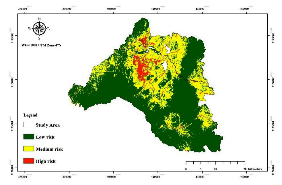
การศึกษาครั้งนี้มีวัตถุประสงค์เพื่อวิเคราะห์ปัจจัยที่มีความสัมพันธ์ต่อการบุกรุกพื้นที่ป่า และพัฒนาจัดทำแผนที่พื้นที่เสี่ยงต่อการบุกรุกพื้นที่ป่าในเขตรักษาพันธุ์สัตว์ป่าลุ่มน้ำปาย จังหวัดแม่ฮ่องสอน ในการวิเคราะห์เชิงพื้นที่ ข้อมูลจุดที่พบการบุกรุกพื้นที่ป่าได้มาจากระบบลาดตระเวนเชิงคุณภาพ (Smart Patrol System) และระบบติดตามการเปลี่ยนแปลงพื้นที่ป่าอัจฉริยะ (Intelligent Forest Monitoring System) ในช่วงปี พ.ศ. 2564–2568 โดยประยุกต์ใช้เทคโนโลยีระบบสารสนเทศภูมิศาสตร์ (Geographic Information System: GIS) ร่วมกับแบบจำลอง Maximum Entropy (MaxEnt) เมื่อวิเคราะห์ร่วมกับปัจจัยแวดล้อมทางภูมิศาสตร์ที่คาดว่ามีอิทธิพลต่อการบุกรุกพื้นที่ป่า จำนวน 4 ปัจจัย ได้แก่ ความสูงจากระดับน้ำทะเลปานกลาง ความลาดชัน ระยะห่างจากถนน และระยะห่างจากแม่น้ำ ผลการศึกษาพบจุดการบุกรุกพื้นที่ป่าจำนวน 76 จุด โดยปัจจัยที่มีอิทธิพลต่อการเกิดการบุกรุกพื้นที่ป่ามากที่สุด คือ ระยะห่างจากถนน รองลงมา ได้แก่ ความสูงจากระดับน้ำทะเลปานกลาง ความลาดชัน และระยะห่างจากแม่น้ำ ตามลำดับ ผลการวิเคราะห์เชิงพื้นที่สามารถจำแนกระดับความเสี่ยงต่อการบุกรุกพื้นที่ป่าออกเป็น 3 ระดับ ได้แก่ พื้นที่เสี่ยงต่ำ มีเนื้อที่ 468,991 ไร่ คิดเป็นร้อยละ 62.78 ของพื้นที่ศึกษา พื้นที่เสี่ยงปานกลาง มีเนื้อที่ 251,309 ไร่ คิดเป็นร้อยละ 33.64 และพื้นที่เสี่ยงสูง มีเนื้อที่ 26,794 ไร่ คิดเป็นร้อยละ 3.59 โดยพื้นที่เสี่ยงสูงส่วนใหญ่กระจายตัวอยู่ในอำเภอปางมะผ้า อำเภอปาย และอำเภอเมืองแม่ฮ่องสอน ผลการศึกษาครั้งนี้แสดงให้เห็นถึงศักยภาพของการประยุกต์ใช้ระบบสารสนเทศภูมิศาสตร์และแบบจำลอง MaxEnt ในการประเมินพื้นที่เสี่ยงต่อการบุกรุกพื้นที่ป่า ซึ่งสามารถนำไปใช้เป็นข้อมูลเชิงพื้นที่สำหรับการวางแผน และการจัดการทรัพยากรป่าไม้ เพื่อป้องกัน และบรรเทาปัญหาการบุกรุกพื้นที่ป่าได้อย่างมีประสิทธิภาพในพื้นที่ศึกษา
คำสำคัญ: ระบบสารสนเทศภูมิศาสตร์ (GIS) การบุกรุกพื้นที่ป่า แบบจำลอง Maximum Entropy (MaxEnt) โมเดลเชิงพื้นที่ พื้นที่เสี่ยง
Abstract
This study aimed to analyze the factors associated with forest encroachment and to develop a spatial risk map of forest encroachment in the Lum Nam Pai Wildlife Sanctuary. The encroachment occurrence data were derived from the Smart Patrol System and the Intelligent Forest Monitoring System during period 2021–2025. A statistical modeling approach was applied using the Maximum Entropy (MaxEnt) model to assess the relationship between encroachment and four key environmental variables: elevation, slope, distance to roads, and distance to stream. A total of 76 encroachment points were identified. The results indicate that distance to roads was the most influential factor, followed by elevation, slope and distance to stream. The spatial analysis classified the study area into three risk levels: low-risk areas accounted for 468,991 rai (62.78%), moderate–risk areas covered 251,309 rai (33.64%), and high–risk areas comprised 26,794 rai (3.59%).The highest–risk zones were predominantly located in Pang Mapha District, Pai District, and Mueang Mae Hong Son District. These findings provide essential spatial infor-mation to support forest protection planning and management strategies aimed at mitigating forest encroachment in the study area.
Keywords: Geographic Information Systems (GIS), Forest encroachment, MaxEnt, Spatial modeling, Risk mapping
Downloads
Article Details

This work is licensed under a Creative Commons Attribution-NonCommercial 4.0 International License.
References
Boonyanuphap, J. (2004). Application of Geographic Information System for Assessing Risk area of Forest Encroachment in Protected Areas. Bangkok: Faculty of Forestry, Kasetsart University. (in Thai)
Chitiphan, P. (2024). Application of Geographic Information System to Evaluate Areas at Risk of Illegal Logging on Conservation Areas in Mae Hong Son Province. Master’s Thesis, Phrae: Maejo University, Phrae Campus. (in Thai)
Critchlow, R., Plumptre, A. J., Driciru, M., Rwet-siba, A., Stokes, E. J., Tumwesigye, C., Wanyama, F., and Beale, C. M. (2015). Spatiotemporal trends of illegal activities from ranger–collected data in a Ugandan national park. Conservation Biology, 29(5), 1458–1470.
Department of National Parks, Wildlife and Plant Conservation. (2023). Annual Report on Forest Protection and Suppression of Forest Law Offenses for The Fiscal Year 2023. Bangkok: Ministry of Natural Resources and Environment. (in Thai)
Eastman, J. R. (2012). IDRISI Selva Manual. Worcester, MA: Clark Labs, Clark University.
Elith, J., Phillips, S. J., Hastie, T., Dudí, M., Chee, Y. E., and Yates, C. J. (2011). A statistical explanation of MaxEnt for ecologists. Diversity and Distributions 17(1): 43–57.
Farr, T. G., Rosen, P. A., Caro, E., Crippen, R., Duren, R., Hensley, S., Kobrick, M., Paller, M., Rodriguez, E., Roth, L., Seal, D., Shaffer, S., Shimada, J., Umland, J., Werner, M., Oskin, M., Burbank, D., and Alsdorf, D. (2007). The Shuttle Radar Topography Mission. Reviews of Geo-physics 45(2): RG2004.
Food and Agriculture Organization. (2020). Global Forest Resources Assessment 2020. Rome: Author.
Fox, J., Castella, J. C., and Ziegler, A. D. (2009). Swidden, rubber and carbon: Can REDD+ work for people and the environment in Montane Mainland Southeast Asia. Global Environmental Change 19(3): 307–317.
Geist, H. J., and Lambin, E. F. (2002). Pro-ximate causes and underlying driving forces of tropical deforestation. BioSci-ence 52(2): 143–150.
Hansen, M. C., Krylov, A., Tyukavina, A., Potapov, P. V., Turubanova, S., Zutta, B. R., Turubanova, S., Zutta, B., Suspense, I., Margono, B., Stolle, F., and Moore, R. (2016). Humid tropical forest disturbance alerts using Landsat data. Environmental Research Letters 11(3): 034008.
Intergovernmental Panel on Climate Change. (2021). Sixth Assessment Report.
Kumar, S., and Stohlgren, T. J. (2009). MaxEnt modeling for predicting suitable habitat. Ecological Modelling 220(9–10): 1338–1343.
Lambin, E. F., Geist, H. J., and Lepers, E. (2003). Dynamics of land–use and land–cover change. Annual Review of Environment and Resources 28: 205–241.
Li, W., Guo, Q., and Elkan, C. (2020). A com-parison of species distribution modeling methods. Ecological Modelling 221: 144–151.
Long, J. A., Nelson, T. A., and Wulder, M. A. (2016). Regional scale characterization of forest fragmentation using satellite imagery. Forest Ecology and Manage-ment 378: 120–132.
Ministry of Natural Resources and Environment. (2024). Annual Report 2023 (Aca-demic Report). Bangkok: Ministry of Natural Resources and Environment. (in Thai)
Phillips, S. J., and Dudik, M. (2008). Modeling of species distributions with Maxent: New extensions and a comprehensive evaluation. Ecography 31(2): 161–175.
Phillips, S. J., Anderson, R. P., and Schapire, R. E. (2006). Maximum entropy modeling of species geographic distributions. Ecological Modelling 190(3–4): 231–259.
Pornpan, J. (2011). Risk analysis of forest crimes using Geographic Information Systems in National Reserved Forests, Tak Province. Bangkok: Master’s Thesis, Kasetsart University. (in Thai)
Reiche, J., Mullissa, A., Slagter, B., Gou, Y., Tsendbazar, N.-E., Odongo-Braun, C., Vollrath, A., Weisse, M. J., Stolle, F., Pickens, A., Donchyts, G., Clinton, N., Gorelick, N., Herold, M. (2021). RADD: Forest disturbance alerts based on Sen-tinel–1 radar data integration. Environmental Research Letters 16(2): 024005.
Swets, J. A. (1988). Measuring the accuracy of diagnostic systems. Science 240(4857): 1285–1293.
Temchai, T. (2021). Application of Geogra-phic Information System to Assess Risk Areas for Agricultural Encroachment in Upper Bang Kloi, Kaeng Krachan National Park. Napaphet Journal, Na-tional Park Innovation Research and De-velopment Center, Phetchaburi Province. (in Thai)
Torlarp K., Kanitin S., and Arnon C. (2016). Application of geographic information system for site quality classification of natural Teak (Tectona grandis L.f.) in Mae Yom National Park, Phrae Province. Nakhon Sawan Rajabhat University Science and Technology Journal 8(8): 62–72. (in Thai)
Trisurat, Y., Kanchanasaka, B., and Kreft, H. (2014). Assessing potential effects of land use and climate change on mammal distributions in northern Thailand. Wildlife Research 41(6): 522–536.
Ziegler, A. D., Fox, J. M., and Xu, J. (2012). The rubber juggernaut. Science 324(5930): 1024–1025.